Global Water Watch
Democratizing earth’s data on water resources
Societies and economies
Societies and economies are under threat because of the unreliability of per capita water resources due to climate change, non-sustainable use and political instability. Worldwide water information is essential to address this fundamental challenge.
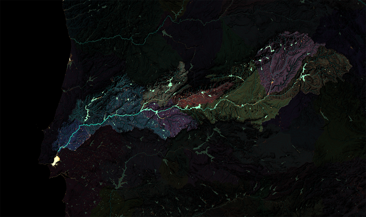
Satellite data and machine learning
We use AI to identify and classify existing water bodies and to generate information about water dynamics in near-real-time. Water variables derived directly from satellite images without proper interpretation are inadequate for decision-makers facing questions like “How much water is stored in my reservoir?”, “Do we have enough water to irrigate crops this year?”, “How does the upstream country manage its water resources?”.
Multiple Use-case scenarios
Red Cross
Lorem ipsum dolor sit amet, consectetuer adipiscing elit. Aenean commodo ligula eget dolor. Aenean massa. Cum sociis natoque.
Lorem ipsum
Lorem ipsum dolor sit amet, consectetuer adipiscing elit. Aenean commodo ligula eget dolor. Aenean massa. Cum sociis natoque.
Dolor sit amet
Lorem ipsum dolor sit amet, consectetuer adipiscing elit. Aenean commodo ligula eget dolor. Aenean massa. Cum sociis natoque.
Roles in this partnership
Deltares will focus on remote sensing and machine learning algorithms in the field of water and the subsoil. WRI’s role in the project is to work on front-end user requirements and use case development. WWF’s role is to be involved in stakeholder engagement and convening dialogue with local communities. Google.org is the philanthropic arm of Google. Their goal is to help solve some of humanity’s biggest challenges — combining funding, innovation, and technical expertise to support underserved communities and provide opportunity for everyone.
Product roadmap
Project awarded - April 2021
To stimulate access to water information, the Dutch research institute Deltares has – with its partners World Resources Institute (WRI) and World Wide Fund (WWF) – received financial support from Google.org for the development of an app containing world-wide, high-resolution, near-real-time, water data.
Scientific paper submitted - March 2022
We are working on a paper explaining our new methods to detect and monitor reservoirs.
Milestone product - Start 2023
Lorem ipsum dolor sit amet, consectetuer adipiscing elit. Aenean commodo ligula eget dolor. Aenean massa.
Team
Gena Donchyts
Principal investigator,
Deltares
Hessel Winsemius
Lead Hydrologist,
Deltares
Alexis Morgan
Use case lead,
WWF
Charles Iceland
Use case lead,
WRI
Fedor Baart
Web,
Deltares
Roeli Suiker
Communication expert,
Deltares
Funding
The financial support for the development of the app was covered by the Google.org Impact Challenge on Climate.